Standing at Africa's Edge: The Lighthouse of Cap Angela, Tunisia
Discover Cap Angela in Tunisia—Africa's northernmost point. Explore the 1890 French colonial lighthouse, dramatic limestone cliffs, local fishing communities, and why this windswept cape 22km from Ichkeul UNESCO wetlands deserves a spot on your North Africa itinerary.
TUNISIALIGHTHOUSESITES TO VISIT
Zayera Khan
12/15/20254 min read
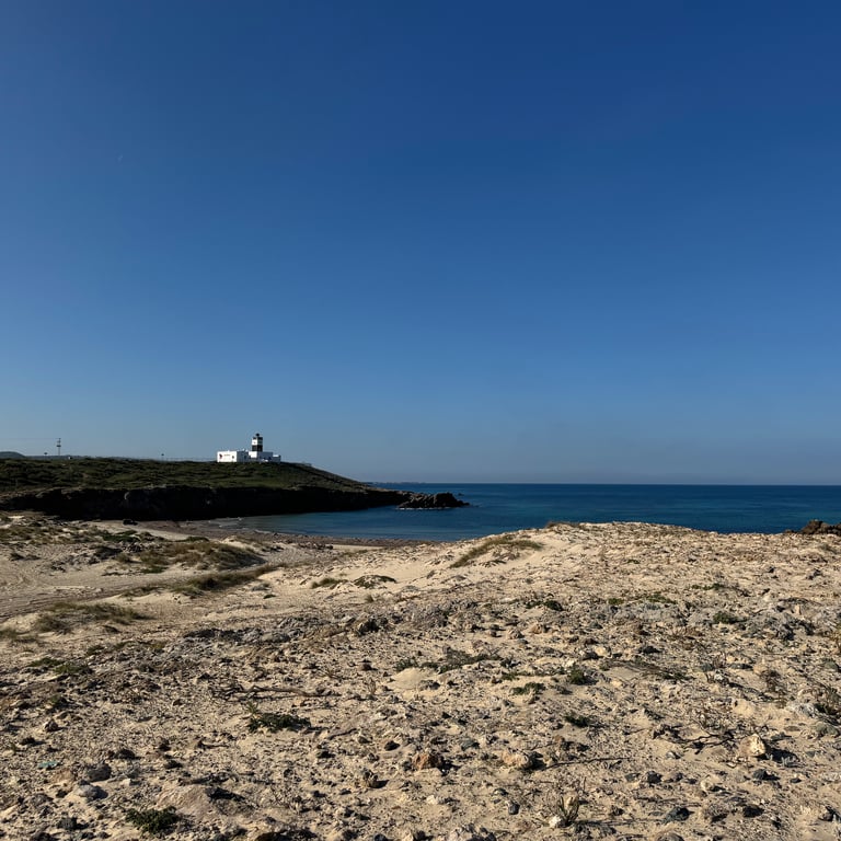
The Landscape: Where Atlas Meets Sea
There's something quietly powerful about standing at the edge of a continent.
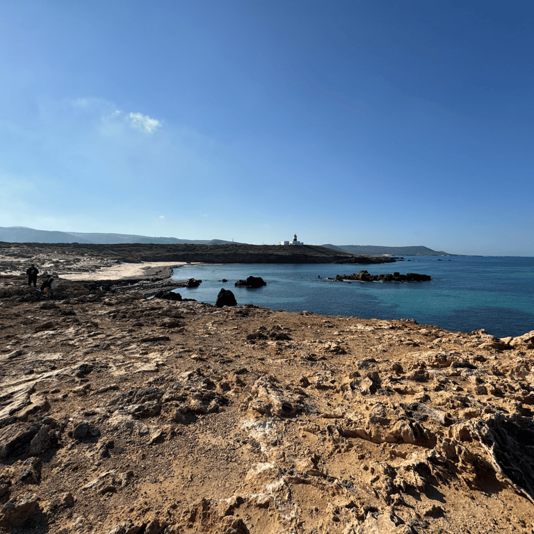
Cap Angela doesn't announce itself. No crowds. No souvenir shops. Just a black-and-white lighthouse on windswept cliffs, marking where Africa finally yields to the Mediterranean Sea. This is the northernmost point of the African continent. The geology here tells an ancient story. The cape forms part of the Tell Atlas mountain range extension in northern Tunisia, dominated by sedimentary limestone formations from the Eocene period. These aren't gentle shores—rugged cliffs rise sharply from the sea, where persistent wave action has sculpted sea caves and undercut ledges along the shoreline.
The coastline alternates between dramatic rocky outcrops and stretches of fine sand beach extending along the Mediterranean. Sheltered coves hide small sandy beaches, perfect for those willing to explore beyond the main viewpoints.
The vegetation is quintessentially Mediterranean. Drought-resistant species dominate—olive trees, mastic trees, and thorny shrubs adapted to semi-arid conditions and saline winds. This maquis-like scrubland, with its aromatic herbs and hardy bushes, provides foraging ground for wildlife and a habitat for migratory birds travelling the Central Mediterranean Flyway.
The local climate is Mediterranean, with mild wet winters averaging 11–15°C and hot dry summers. Annual precipitation totals around 500–600 mm, concentrated in winter months. Grokipedia
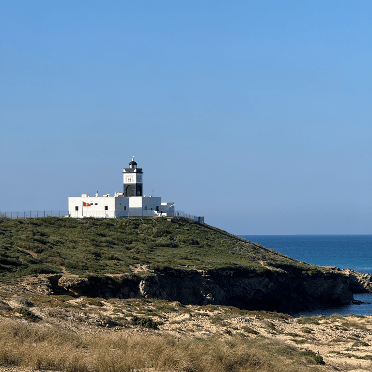
A Lighthouse with Colonial Roots
The lighthouse was put into service on July 30, 1890, during French colonial rule over Tunisia. Its construction was overseen by Paul Massicault, the French Resident-General. The cape itself may owe its name to Engela, Massicault's wife —though alternative theories suggest it commemorates a cargo ship, or stems from a romantic local legend about a beautiful woman who captivated a navigator. I find the uncertainty interesting. History isn't always neat.
What we do know: it's a square tower with gallery and lantern, fifteen metres tall, rising above a single-storey keeper's house. The design is distinctive—the tower is painted black with a wide white horizontal band below the gallery, while the building beneath is white.
The light sits at a focal height of 38 metres above sea level, emitting a white flash every 2.5 seconds with a maximum range of fifty kilometres. There's also a red sector light to the southwest, near the shore, with a 45-kilometre range—designed to warn ships of the hidden reefs that once caused shipwrecks along this coastline.
Local fishermen still tell stories of ships wrecked on hidden reefs north of the headland before the lighthouse was erected. Lighthouse-index For Mediterranean sailors, this light has long served as a landmark for safe passage into the Gulf of Tunis.
Today the lighthouse is managed by Tunisia's Service des phares et balises (SPHB) Wikipedia. It continues its original navigational purpose after more than 130 years—a quiet testament to French engineering and the maritime importance of this coastline.
The People: Fishermen and Small Villages
The road to Cap Angela passes through a small village where you'll likely need to stop and ask directions Kuo Vadis—the final stretch is dirt road, and signage is minimal.
Adjoining the forest is a small corner of fishermen who practice coastal and traditional fishing. This isn't tourism-driven livelihood; these are families who've worked these waters for generations. In Bizerte's old port, fishermen relax by their nets collected on the cobblestoned pier Kuo Vadis, happy to pose for photos before returning to their conversations.
The region around Bizerte—Tunisia's most densely populated area in the northeast—is very hilly, with the summits of the Mogod mountains exceeding 500 metres. Blue Green Atlas But at Cap Angela itself, development remains sparse. A few houses cluster near the louage drop-off point. The rest is forest, scrubland, and sea.
What You'll Find at the Cape
Two monuments mark Africa's northernmost point—a sculpture of the continent with an arrow pointing south (toward Cape Agulhas, South Africa, 8,060 km away), and plaques inscribed with "Point le plus septentrional du continent Africain" alongside the precise coordinates.
From the lighthouse area, visitors can enjoy panoramic views over the Mediterranean toward Sicily and the Gulf of Tunis. The surrounding landscape features rocky shoreline with low scrub, popular for watching sunrises and migratory seabirds. Lighthouse-index
An interesting quirk: about 50 metres west of the monument, there's another rocky outcrop that appears to reach slightly further north. During high tide, water and rocks separate it from the mainland. Some tourists swim over. Whether it's truly part of "mainland" Africa or a separate islet is a question for the pedantic—but that's part of the charm.
Getting There
Cap Angela lies about 15 kilometres from Bizerte and roughly 70 kilometres north of Tunis.
From Tunis, take a louage from the Gare Routière Nord at Bab Saadoun to Bizerte—about one hour covering 64 km, for around 5-6 Tunisian dinars. From Bizerte, take a taxi or public bus that runs along the Bizerte-Ras Angela road to a stop near a cluster of houses, approximately 15 km away and taking 30 minutes: Bus fare is the cheapest, 1 dinar. Be aware: Louage drivers might try to scam you and will ask for 50 dinar to drive you there and back. You can negotiate for the time you spend there, but just be careful as the prices variates. One guy offered me first 50 dinars and then went down to 30 dinars. But I went with public bus and was lucky to find locals to guide me.
Worth to know the final 1 km deteriorates into a dirt path unsuitable for most vehicles, necessitating a walk.
Download an offline map. I recommend Maps.me for better pedestrian paths than Google Maps. Speaking French, with help when asking for directions.
Worth the Detour?
If you're already exploring northern Tunisia, absolutely.
Combine it with a couple of hours in Bizerte—the old port is bathed in golden light at sunset, with colourful buildings reflecting off the water and an ancient medina worth wandering. The charming harbour has Andalusian architecture.
Cap Angela won't take more than a few hours. But standing where an entire continent ends—where 130 years of maritime history meets dramatic cliffs and the endless Mediterranean—that stays with you.
Have you visited Africa's northernmost point? I'd love to hear about your experience in northern Tunisia.
Cap Angela Tunisia, lighthouse Tunisia, northernmost point of Africa, Ras Ben Sakka, Bizerte day trip, Tunisia travel guide, French colonial lighthouse