Bømoen: Where Ice Shaped the Land and Water Still Sings
Discover the glacial origins and natural beauty of Bømoen near Voss, Norway. This blog post explores how ancient meltwater shaped the region's unique water rapids and landscape—no mining or quarries involved. Learn about Bømoen’s geology, hiking trails, and peaceful forest tarns, and uncover the story of a Norwegian military site turned natural haven. Perfect for nature lovers, hikers, and fans of Norwegian travel and geology.
NORWAY
Zayera Khan
5/18/20252 min read
Bømoen: Where Ice Shaped the Land and Water Still Sings
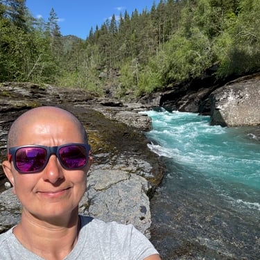
Nestled just outside the vibrant town of Voss in Western Norway, Bømoen offers more than just scenic hiking trails and quiet forest walks—it holds a deep geological story written in stone, water, and time. While many associate the region with adrenaline sports or the cultural heartbeat of Voss, Bømoen is a tranquil counterpoint where the whispers of the Ice Age still echo in the rapids and the land formations.
A Geological Legacy Carved by Ice
Approximately 11,000 years ago, as the last Ice Age began to retreat, this part of Norway was dramatically transformed. Bømoen was once covered by a thick glacier. As the ice melted, powerful meltwater rivers coursed through the terrain, carrying immense loads of gravel, sand, and stone. These rivers sculpted the landscape into a sandur—a type of outwash plain composed of glacial sediments.
The flat terrain we see today is the result of this process. But the story doesn’t end there. Isolated blocks of ice, left behind by the glacier, slowly melted and formed kettle holes—depressions in the earth that filled with water. One of the most notable examples in Bømoen is Ostjørni, a small, calm tarn nestled in the forest—a quiet reminder of the ice that once dominated this valley.
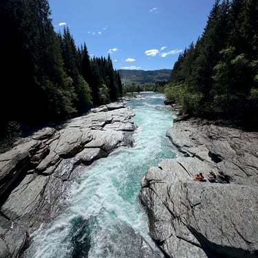
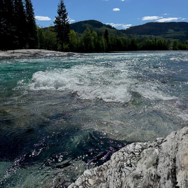
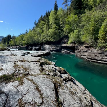
Water Rapids Without Industry
Contrary to some local legends and misconceptions, Bømoen was never the site of slate mining or industrial quarrying. The area's water rapids—vibrant and ever-moving—are entirely natural formations. They are not the byproduct of human intervention but the result of glacial runoff carving through sediment over millennia.
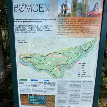
These rapids, which can be seen in certain areas around the Bømoen trail system, especially during snowmelt or after rainfall, reflect the ongoing interaction between water and land. The sound of rushing water weaving through the mossy rocks is both soothing and primal—a sonic memory of a time when nature alone shaped the earth.
Military History Meets Natural Beauty
While Bømoen’s geological roots go back to prehistory, its modern human history is relatively recent. In the 19th and 20th centuries, Bømoen served as a military training camp. The area was developed with barracks and facilities, many of which have been preserved or repurposed today. After the military withdrew in the early 2000s, the space transitioned into a zone for outdoor recreation, local sports clubs, and sustainable forestry.
The military presence inadvertently helped preserve much of the natural environment, preventing large-scale development and maintaining access to extensive forest trails and wetlands. Today, locals and visitors alike enjoy hiking, running, and birdwatching in the area.
Visiting Bømoen Today
Whether you’re a geologist, a history buff, or a traveler seeking tranquility in nature, Bømoen offers a rare convergence of narratives. It’s a place where glacial history is visible underfoot, where natural water features bring the past into the present, and where human history has left only a light footprint on a resilient landscape.
Bring your hiking boots, your curiosity, and your camera. And when you hear the sound of rapids in the distance, remember: you’re hearing a river born of ancient ice.